About Tutwiler
History
In 1899 Tom Tutwiler, a civil engineer for a local railroad, made his headquarters seven miles northwest of Sumner. The town of Tutwiler was founded and named for him. When the railroad was built the first depot erected was a two story building and the town was given the top floor for a school. Captain H.B. Fitch built and operated the first store. His wife took charge of the school, which began with five pupils.[citation needed]
In 1905 the town was incorporated, and W.E. Fite was Mayor, and J.O. Clay was the depot agent. In 1900 the Illinois Central Railroad, running from Yazoo City to Lambert, crossed at Tutwiler where the company built a railroad yard.
In 1928 a high school was built at a cost of $40,000. The town grew rapidly until 1929 when the railroad yard was moved to Clarksdale. At that time the population and business began to decline. The population in 1929 before the railroad yard was moved was 1,010 people.
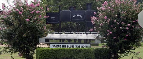
Like many other towns in the Mississippi Delta, Tutwiler stakes a claim to being the "birthplace of the blues". This is the site where W. C. Handy reportedly "discovered" the blues in 1903, on a train platform in the town. Handy had heard something akin to the blues as early as 1892, but it was while waiting for an overdue train to Memphis that he heard an itinerant bluesman (legend says it was a local field hand named Henry Sloan) playing slide guitar and singing about "goin' where the Southern cross the Dog," referring to the junction of the Southern Railway and Yazoo and Mississippi Valley Railroad farther south. (The Y&D railroad was locally called the "Yellow Dog".) Handy called it "the weirdest music I had ever heard." A Mississippi Blues Trail marker honoring Handy was erected at the site on November 25, 2009.
Demographics
As of the census[3] of 2000, there were 1,364 people, 410 households, and 316 families residing in the town. The population density was 1,020.6 people per square mile (393.0/km²). There were 429 housing units at an average density of 321.0 per square mile (123.6/km²). The racial makeup of the town was 11.80% White, 87.32% African American, 0.29% Native American, 0.37% Asian, and 0.22% from two or more races. Hispanic or Latino of any race were 0.44% of the population.
There were 410 households out of which 35.9% had children under the age of 18 living with them, 34.4% were married couples living together, 34.4% had a female householder with no husband present, and 22.7% were non-families. 20.0% of all households were made up of individuals and 11.0% had someone living alone who was 65 years of age or older. The average household size was 3.33 and the average family size was 3.82.
In the town the population was spread out with 33.6% under the age of 18, 11.7% from 18 to 24, 26.1% from 25 to 44, 16.3% from 45 to 64, and 12.2% who were 65 years of age or older. The median age was 29 years. For every 100 females there were 80.4 males. For every 100 females age 18 and over, there were 76.3 males.
The median income for a household in the town was $18,958, and the median income for a family was $22,857. Males had a median income of $21,364 versus $17,222 for females. The per capita income for the town was $7,177. About 32.1% of families and 38.5% of the population were below the poverty line, including 45.5% of those under age 18 and 31.1% of those age 65 or over.